Drones provide efficiency, speed, and safety in Scan to BIM. Capturing high-resolution point clouds of large spaces reduces risks and trim timelines while improving data accuracy for enhanced BIM models.
Leading CAD Outsourcing Company offers solutions of Engineering CAD Services, Design Drafting & 3D Modeling
Email us:
info@truecadd.com
info@truecadd.com
Leading CAD Outsourcing Company offers solutions of Engineering CAD Services, Design Drafting & 3D Modeling
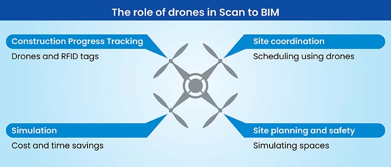
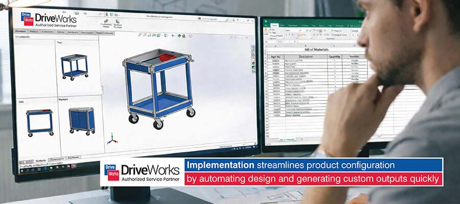
Benefits of Using Drones for Point Cloud Data Collection in Scan to BIM
Updated on June 2nd, 2026
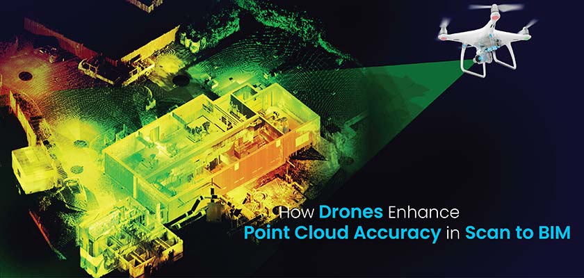
Table of Contents
- How drone technology is transforming Scan to BIM processes
- How do drones collect point cloud data?
- Features that make drones ideal for Scan to BIM
- Benefits of Drones in Scan to BIM
- Applications of drones in Scan to BIM workflows
- Challenges and solutions in drone-based point cloud data collection
- Future trends of drone technology in construction
- FAQS on drones for BIM processes
- Conclusion
In Scan to BIM workflows, traditional point cloud data collection methods often present significant challenges in achieving data completeness and registration accuracy. Multiple scanning positions, occlusions, and access limitations frequently result in data gaps, especially in complex architectural elements and elevated structures.
Drone-based point cloud data collection fundamentally transforms this data acquisition process, delivering comprehensive spatial data with superior coverage of complex geometries. The technology’s ability to capture consistent point density across elevations, combined with systematic flight patterns, results in highly structured datasets that streamline subsequent processing workflows.
The benefits manifest primarily in point cloud data quality and processing efficiency. The combination of comprehensive aerial coverage and systematic data collection patterns leads to improved point cloud registration accuracy and enhanced BIM integration capabilities. These improvements directly translate to more efficient scan to BIM modeling workflows.
How drone technology is transforming Scan to BIM processes
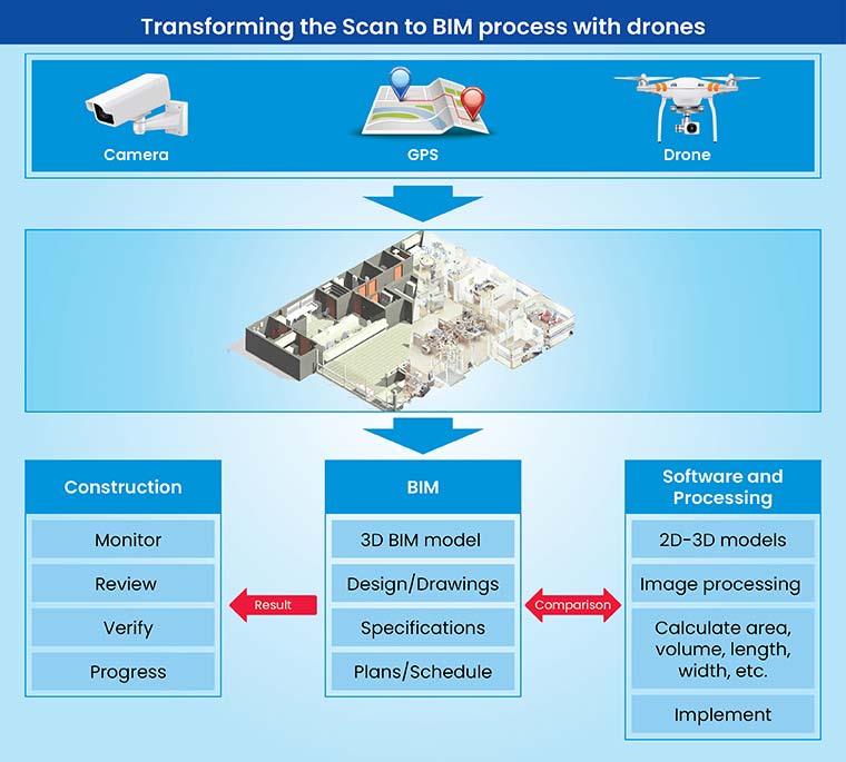
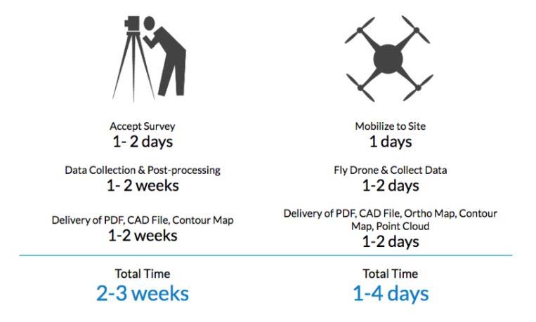
Legacy methods like terrestrial laser scanners can be labor intensive, time consuming, and costly. They often need specialized expertise, which leads to potential time overruns and greater costs.
Drones are faster, more efficient, and cost-effective solutions as they need minimal resources, enable faster data capture, and have the ability to access hard-to-reach spaces, while reducing manual labor with drones and time, which leads to lower project costs.
Point Cloud generation using drones can seamlessly integrate with Revit to enable designers and BIM modelers to create accurate 3D models of built structures. This makes Scan-to-BIM workflow optimization seamless, which facilitates comprehensive renovation, As-Built documentation, and construction planning.
How do drones collect point cloud data?
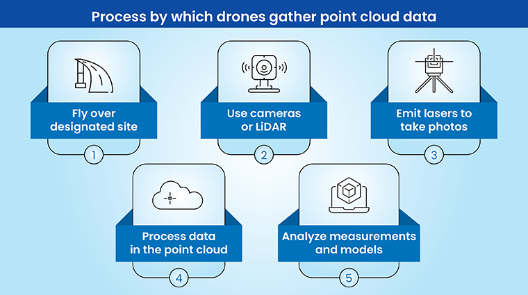
Drones use advanced sensors, including photogrammetry and LiDAR (Light Detection and Ranging) algorithms and tools to capture accurate spatial data. LiDAR utilizes laser pulses to measure distances, while photogrammetry utilizes high-resolution photographs to generate accurate 3D models for surveyors.
Drone photogrammetry includes documenting overlapping aerial images with high-resolution cameras. Specialized tools process these photos to generate maps and 3D Scan to BIM models by identifying points and enabling position triangulation.
Revit imports and aligns drone-driven point cloud data while providing users with the ability to achieve faster processing, extract measurements, generate sections and assess the existing structure.
Features that make drones ideal for Scan to BIM
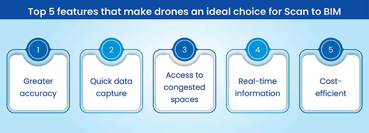
Drones reinforced with high-resolution cameras capture in-depth aerial images, which enables the creation of accurate Revit Scan to BIM models for site topography, built structures, and surrounding areas.
Real-time project insights through drones provide quick feedback on site progress and on-site conditions. This allows quick flagging of potential problems, accelerated decision making, and effective project management.
Point Cloud data provided by drones is imported into Revit using formats like RCS and RCP. Revit’s point cloud tools help users align, visualize and modify data within the BIM environment. This enables precise 3D modeling using snapping to points, extracting measurements, and creating sections from a dense point cloud, which streamlines the Scan to BIM workflow.
Top 5 benefits of drones in Scan to BIM
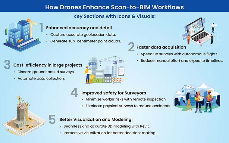
Drones offer quick and cost-effective solutions to collect high-resolution point cloud data. This technology offers high efficiency, reduces risks, and improves accuracy in various applications, including surveying, asset management, and construction.
1. Enhanced accuracy and detail in point cloud data
Drones enhance point cloud accuracy by using high-resolution cameras and LiDAR sensors to capture precise geolocation data and generate sub-centimeter accurate 3D models.
- High-resolution data capture: Drones equipped with cameras exceeding 100 megapixels capture overlapping photos with precise geolocation data. These images are processed using photogrammetry software to generate dense point clouds with sub-centimeter accuracy, enabling the creation of Digital Surface Models (DSMs) and Digital Terrain Models (DTMs).
- LiDAR-driven precision: LiDAR drones use laser pulses with multiple wavelengths and pulse repetition rates to measure distances and capture intricate details of complex spaces. This includes scanning vegetation canopies to reveal terrain features, capturing the detailed geometries of facades, and accurately measuring distances in GPS-restricted areas.
- Seamless integration with BIM software: Point cloud data, available in .rcs or .rcp formats, can be directly imported into Revit. Revit’s point cloud tools allow users to precisely register and align data with project coordinates, facilitating accurate 3D Scan-to-BIM modeling by generating required sections and extracting spatial dimensions from the point cloud.
2. Faster data acquisition
Drone surveying deploys effective autonomous navigation and flight planning to enable quick coverage of large spaces with minimal ground control points. Automated data acquisition reduces the time for site surveying compared to legacy techniques, expediting project schedules and enabling faster TAT for deliverables.
Revit’s native support for Point Cloud data helps with the seamless integration of drone-created point clouds. This removes the need for time-consuming file conversions and costly third-party software. Users can utilize Revit’s built-in tools to measure, visualize, and section the point cloud data, which facilitates effective analysis and 3D modeling with drones for improved Scan to BIM workflows.
 Source: forconstructionpros.com
3. Cost efficiency in large-scale projects
Drones enhance cost efficiency in large-scale projects by automating data collection, reducing labor expenses, minimizing the need for ground-based surveying, and accelerating project timelines.
- Automated data capture and reduced labor costs: Drones with high-resolution cameras and photogrammetry software automate site data collection for building design, eliminating the need for manual measurements and surveying. This reduces labor costs and minimizes ambiguities in data collection, ensuring more precise and efficient results.
- Cost-effective aerial surveys: LiDAR and photogrammetry-powered drones lower the cost of aerial surveys by reducing reliance on expensive ground-based systems and large survey teams. Their rapid data acquisition capabilities further cut labor expenses and shorten project timelines.
- Efficient large-scale project management: Drones equipped with advanced sensors and automated flight planning effectively map extensive areas, track construction progress, and monitor infrastructure. This minimizes manual labor, accelerates data collection, enables early issue detection, reduces costly rework, and ensures timely project completion.
4. Improved safety for surveyors
Using Drones equipped with thermal and visual sensors enables quick remote inspection of hazardous spaces, which include unstable structures, hard-to-access spaces, or buildings with chemical issues. This reduces the risk of exposing workers or surveying personnel to dangerous situations, while ensuring worker safety.
Drones foster remote data collection, help with site analysis and inspections without the need to physically access hazardous spaces. This promotes adherence to safety regulations and lowers the risk of injuries or accidents.
Operating drones by adhering to safety regulations, including maintaining safe distances from structures and personnel, using fail-safe mechanisms, complying with no-fly zones, and ensure safe drone application for data acquisition.
5. Better visualization and modeling
Revit Scan to BIM modeling uses interoperable file formats that include .rcs and .rcp to facilitate accurate 3D mesh creation with a tool feature like “Create topography from the Point Cloud”. This supports accurate 3D modeling of geometries, which incorporates minute details on facades and site features for realistic visualizations.
Furthermore, the rendering engine from Revit helps with high-quality and realistic renderings for lighting, materials, and spatial context to enhance overall presentation. Furthermore, interactive visualizations and VR experiences extracted from the Revit model enable an immersive exploration of design, engagement, and faster decision making.
Success stories of point cloud scan to BIM modeling
The following case studies demonstrate how Scan to BIM modeling has helped a famous coffee outlet project achieve an accurate As-Built model and enabled time savings for a commercial building.
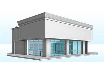
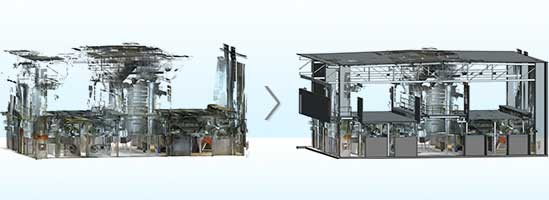
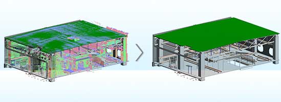
Point Cloud to Revit 3D Modeling for a Retail Coffee Outlet in the USA
A building surveying firm from the USA approached TrueCADD for a retail coffee outlet project. Providing point cloud data drawings, scans, and 360 photos from drones and laser scanners, the team navigated various obstacles, including large datasets, low quality scans, and modeling hazards, to begin the project. Based on the data provided, the team created a point cloud to BIM as-built model with elevations, site plans, and sections. A complete Revit file audit was performed to verify the model integrity and quality.
Upon handover of the deliverables, the client was able to:
- Leverage the As-Built model and drawings before the planned schedule
- Analyze the building state with a +- 10mm accuracy in a collaborative space
 Point Cloud to Revit 3D Modeling
 Revit 3D Model Converted from Scan Data
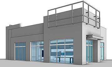
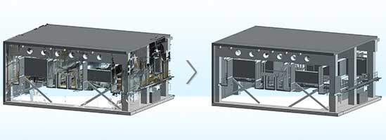
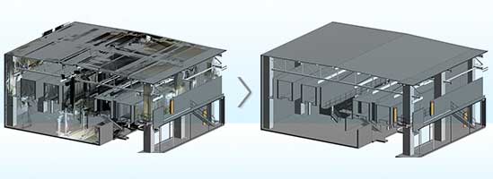
Scan to BIM conversion for a commercial project in Europe
A topographic services company from Europe approached TrueCADD for support on a commercial project. The client provided .rcp files as input, and the TrueCADD team faced several challenges, including managing large point cloud files, working with adjoining boxes, and meeting tight deadlines. Utilizing tools such as Revit, Recap, and AutoCAD, the team successfully delivered Scan to BIM conversion, producing accurate structural models along with basic architectural elements for the commercial building.
Handing over the deliverables to the client led to:
- Time savings in construction
- Accurate load calculations for the new building design
 Point Cloud to 3D CAD Revit Model
 Point Cloud to BIM Model
 Point Cloud to CAD Conversion
 Scan to 3D CAD Model
Applications of drones in Scan to BIM workflows
Drone-driven data extracted from LiDAR can achieve greater accuracy for As-Built models in Revit. This fosters precise documentation for renovation and heritage projects. It also enables an efficient analysis of architectural features and improved planning without invasive surveying techniques.
-
Drone mapping for large-scale construction projects:
Drones equipped with Post-Processed Kinematics (PPK) GPS equipment and high-resolution cameras document detailed imagery for creating precise digital elevation models (DEMs) and orthomosaics. This information helps to create detailed site maps for surveyors with accurate measurements, visualization of urban fabric, simulation and topographic data.
-
Remote monitoring and progress tracking:
Real-time kinematic (RTK) GPS equipment captures real-time aerial data for perpetual site monitoring. This data, coupled with point clouds and orthomosaics, is used in Revit to generate Scan to BIM models and monitor construction progress vs planned schedules. It helps surveyors with volumetric calculations and quantity takeoffs for improved cost control.
Challenges and solutions in drone-based point cloud data collection
Challenges in drones for point cloud data collection include reflective surfaces and dense vegetation, which require accurate flight planning and sensor selection. It also includes issues such as regulatory compliance and weather dependencies.
-
Challenges in drone operations:
Drone flying or surveying needs skilled pilots to move through various terrains, mitigate obstacles, and maintain situational cognizance while complying with licensing needs and airspace regulations. Challenges also include the management of weather conditions, dependable communication links, risk reduction in complex spaces, issuance of required permits, and complying with operational limitations.
-
Solutions for optimized drone performance:
Revit’s point cloud tools help with precise alignment and registration of LiDAR data using the project coordinate system, which enables precise 3D modeling of the built environment for surveying firms. This fosters detailed analysis of complex geometries, including intricate façade details or irregular terrain.
Future trends of drone technology in Scan to BIM
Future trends in drone equipment for Scan to BIM include AI-driven data assessment for drone mapping. AI-driven reality capture enables drones to automatically identify objects and navigate and enhance flight paths for effective and precise 3D mapping.
-
Emerging AI-based technologies for autonomous drone mapping:
AI-driven technology in drone mapping is realized through advanced algorithms that process data in real time from onboard drone sensors like LiDAR and cameras.
These technologies help drones to consider their surroundings, identify and categorize objects, and make smart decisions for data acquisition and navigation. This includes capabilities like dynamically modifying flight paths to prevent obstacle collision, enhancing camera angles for greater coverage, and automatically triggering photo captures based on predefined parameters.
-
Increased focus on sustainability through drone-enabled BIM workflows:
Sustainability in drone-driven Scan to BIM workflows is achieved through the creation of accurate 3D models and data-driven insights. This supports accurate material quantification, enhanced construction planning and effective resource allocation, reducing waste and mitigating the carbon footprint of construction and renovations.
Furthermore, drones support asset monitoring and inspection, while reducing the requirements for on-site visits and lowering carbon emissions.
Conclusion
The integration of drone-based point cloud collection into the Scan to BIM process represents a key advancement in construction data acquisition. The superior spatial coverage and systematic collection patterns fundamentally improve downstream processing efficiency, particularly in point cloud registration and noise reduction phases.
While implementation requires careful consideration of data-handling protocols and processing workflows, the technical advantages in data completeness and geometric accuracy are compelling. And by integrating 3D scans into BIM for intricate structures, drone-based point cloud collection will provide clear technical advantages in achieving high-quality, consistent deliverables.
Streamline your workflows and elevate efficiency with Scan to BIM.
Start your transformation today »FAQs on drones for Point Cloud to BIM processes
The following section delivers answers to common questions on using drones for Scan to BIM processes.
-
Aerial data collection generates point clouds, which are imported within the Revit framework to create 3D models of sites and buildings.
-
Drone photogrammetry utilizes aerial images to generate Revit Scan to BIM models, which offer quick data acquisition, greater coverage, and lower costs.
-
LiDAR drones document accurate 3D data in complex spaces with challenging terrain or vegetation. This enables the creation of accurate models with in-depth geometry.
-
Point clouds from drones are imported in file formats like .rcs and .rcp, where they are used for analysis, measurements, and 3D modeling.
-
While drones deliver advantages, manual surveying may be required for unique tasks that require greater precision or to access hard-to-reach spaces.
-
Drone implementation costs vary based on factors like drone type project size, tools used, and expertise.

Harika Singh
Harika Singh is a published author with over 20 years of experience working with leading organizations in India and the United States. She develops authoritative content on BIM, CAD, VDC, digital engineering, and construction technology. Her expertise lies in translating complex technical concepts into actionable insights that help AEC professionals improve collaboration, efficiency, and project outcomes.
Related Posts
Need help on an ongoing basis?
We establish long term business relationships with clients and are committed to total customer satisfaction.
Home |
Sitemap |
Privacy Policy | Data Security & Confidentiality |
Contact us |
![]()