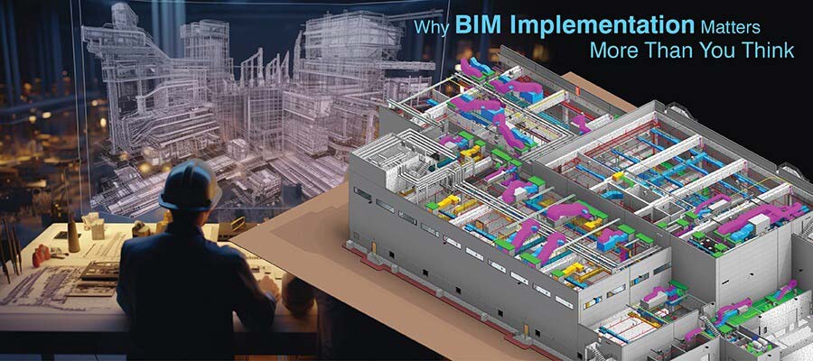
Harnessing the power of Scan to BIM has transformed renovation, retrofitting, and As-Built documentation workflows in the AEC industry. Conversion of 3D laser scans or point clouds of existing buildings into accurate and information-rich 3D models has opened the way for high accuracy in design information, and in calculating measurements of missing components.
Leading CAD Outsourcing Company offers solutions of Engineering CAD Services, Design Drafting & 3D Modeling
Email us:
info@truecadd.com
info@truecadd.com
Leading CAD Outsourcing Company offers solutions of Engineering CAD Services, Design Drafting & 3D Modeling
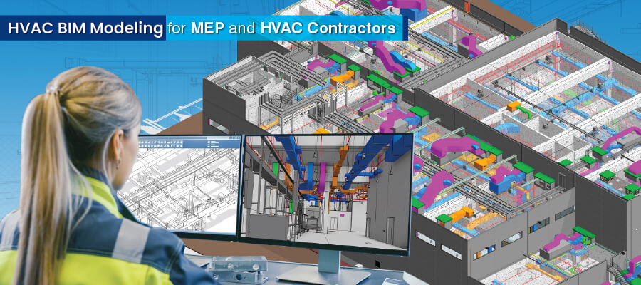
How Scan to BIM transforms the AEC Industry
Updated on May 21st, 2026
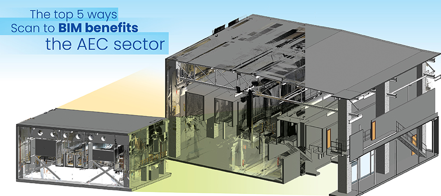
Accurate visualization, clash detection, and effective project management supported by scan to BIM modeling now help renovations align seamlessly with existing structures. This is important for designing and creating digital representations of areas that are difficult to access, in heritage conservation, in urban planning and in other critical AEC work.
Table of Contents
- Definition and Explanation of Scan to BIM
- Understanding Scan to BIM Technology
- Methods of Capturing Point Cloud Data (Laser Scanning, Photogrammetry, LiDAR)
- Top 5 Benefits of Scan to BIM Technology in AEC
- Challenges in adopting Scan to BIM
- Scan to BIM: The Conversion Process
- Role of Advanced Software and Algorithms in Scan to BIM Conversion
- Applications of Scan to BIM in AEC
- Future Trends- Application of AI and ML in Scan to BIM Technology
- Scan to BIM Success Stories
- Conclusion
- FAQs related to Scan to BIM
Definition and Explanation of Scan to BIM
Point cloud to BIM or Scan to BIM is essential today for renovations, retrofitting, and As-Built documentation in architecture and construction. It involves converting raw point cloud data from 3D laser scans into accurate, data-rich, and intelligent 3D BIM models. Point clouds capture the dimensions and shape of existing areas or spaces in a coordinate system.
Specialized software enables surveyors to convert point clouds into 3D BIM models. This allows us to add valuable data including component properties, spatial relationships, and building materials. Conversion of 3D laser scans into scan to BIM models provides architects, engineers, surveyors, and other parties with precise, updated, and real-time data.
Scan to BIM for the AEC industry has workflows and tools to capture and transform physical structures into 3D models. This ensures design precision, preemptive interference detection, and project planning. It reduces errors and improves project scheduling.
The biggest scan to BIM services benefits include improving project visualization, team collaboration, and delivering productive insights for decision-making. Point cloud to BIM enhances precision and efficiency of construction processes, leading to swift and cost-efficient projects.
Understanding Scan to BIM Technology
Point cloud data consists of precise coordinates of objects and surfaces in 3D space. This data is captured by laser scanners or other tools. Each point cloud is defined in X, Y, and Z coordinates to accurately capture positions and shapes of objects. In the AEC industry, point cloud data provides an accurate and detailed interpretation of real-world spaces for accurate analysis, measurements, and visualization.
Methods of Capturing Point Cloud Data (Laser Scanning, Photogrammetry, LiDAR)
Point cloud data capture methods include techniques like Laser Scanning, Photogrammetry, and LiDAR. Laser scanning uses concentrated laser beams to assess object surfaces, while photogrammetry utilizes 2D images from various angles to generate 3D points. LiDAR uses sensors based on lasers to precisely map surfaces making these tools significant in the field of Architecture, Engineering, and Construction (AEC).
Laser Scanning for Point Cloud
Laser scanners capture accurate point cloud data through laser beam emissions by measuring the time it takes for the beam to hit an object and return. This technique generates a detailed 3D data representation of spaces and objects, making it a popular tool in renovations, retrofitting, and As-Built drawings. Laser scanning may use terrestrial laser scanners (TLS) or mobile laser scanners. Today, beyond LiDar, laser scanning mostly refers to stationary TLS used for high density and high-resolution point clouds that are slower to generate and carry both coordinates and RGB and intensity data.
Photogrammetry in Point Cloud
Photogrammetry captures Point cloud data by analyzing 2D photographs from different angles. Common points within these images are identified, and industry-specific software calculates the 3D coordinates to generate an in-depth and precise point cloud. Photogrammetry is versatile, cost-efficient, and used in various fields including forestry, geology, and urban planning.
LiDAR (Light Detection and Ranging)
LiDAR technology uses laser sensors on terrestrial or aerial platforms for distance measurement and creating detailed point cloud depiction of objects and surfaces. It falls under Laser Scanning, but focuses more on time-of-flight measurements. LiDAR equipment emits laser pulses and measures the time taken for them to return after hitting the object surface, allowing accurate 3D mapping. LiDAR sensors can be mounted on drones, vehicles, etc, and they are often used for topographic mapping of wide areas. LiDAR is widely applied for autonomous vehicles, environmental monitoring, and cartography based on its ability to capture high-resolution and large data sets effectively and efficiently.
Top 5 Benefits of Scan to BIM Technology in AEC
Accurate 3D Representation
Point cloud technology or Scan to BIM enables the creation of accurate 3D BIM models of existing structures. Capturing millions of data points through laser scanners delivers a precise 3D visualization of the existing space that includes complex details, spatial relationships, and measurements. This accuracy is invaluable for architects, engineers, and surveyors to ensure designs are aligned with real-world data.
Enhanced Collaboration and Communication
Point cloud to BIM facilitates communication and collaboration among stakeholders in the AEC industry. Detailed Scan to BIM models help surveyors to visualize the project on a single platform. A shared understanding of the project reduces communication ambiguities, mitigates errors, and ensures cohesive teamwork for successful project outcomes.
Streamlined Renovation and Retrofitting
Point cloud to BIM provides a set of efficient processes and tools for renovation and retrofit projects. By generating accurate and information-rich 3D models, surveyors can assess existing space effectively. Identifying clashes, plan changes, and seamless integration of new components with existing ones streamlines renovation and retrofit processes. This reduces costly errors and optimizes resource usage.
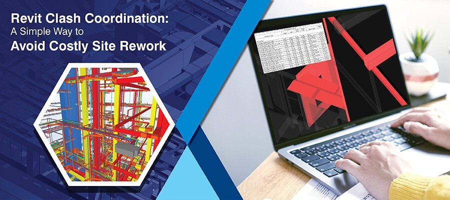
Efficient Clash Detection and Coordination
BIM software supports designers by allowing overlaying of point cloud to BIM models for coordination analysis and clash detection. Identifying interferences between building elements like ducts, pipes, and structural elements on screen in a virtual environment helps resolve issues and reduce site clashes. This approach saves time, improves efficiency and mitigates rework.
Cost and Time Savings
Using point cloud to BIM for renovation and retrofit projects ensures significant time and cost savings for the entire project lifecycle. Accuracy within 3D models provides insights for surveyors to make informed decisions. By reducing errors and rework, construction processes become efficient, reducing the overall project schedule. Precise data from point clouds supports accurate and faster quantity takeoffs (QTO) and improves project planning, optimized resource use and cost savings.
Challenges in adopting Scan to BIM
Data Complexity and Volume
Capturing point cloud data through laser scanners is detailed and dense. Handling a large dataset of millions of data points can be challenging. Processing and managing a high volume of point cloud data to ensure accuracy and effectiveness requires expensive computational resources and a skilled workforce.
Data Integration and Alignment
Enriching point cloud data within BIM models with accuracy can be challenging. Aligning captured point cloud data with existing 3D models or CAD files requires careful attention. Misalignments can lead to inaccuracies, clashes, and problems in the final design. Lack of data integration and alignment results in expensive revisions during renovation and retrofitting.
Interoperability and Software Compatibility
Various software tools used for point cloud processing and 3D modeling can lead to interoperability issues between platforms. It can require additional expertise and effort to address standards, data formats, and compatibility issues that can affect efficient information exchange.
Skill and Expertise Gap
Deploying point cloud to BIM requires a very high level of expertise. Many AEC professionals may lack the skills to manipulate and navigate point cloud data within BIM workflows. Training existing staff or employing specialists in-house can be costly and time-consuming.
Cost and Budget Constraints
Investing in Scan to BIM tools can be expensive for SMBs. It may be challenging to allocate budgets for equipment, personnel and software. Managing costs for updates, licenses, maintenance, and data storage can be difficult without expertise.
Scan to BIM: The Conversion Process
Data Acquisition
Capture site data or existing space using laser scanners, photogrammetry or LiDAR. Generate dense point clouds through laser scanners to accurately represent the physical geometry and structure.
Point Cloud Registration
Multiple scans done from various positions are aligned and registered to generate a single point cloud. Specific software is used to map overlapping points for precise alignment of the unified point cloud data. Accurate and complete scan registration is critical to achieve high precision of the final 3D BIM model.
Point Cloud Processing
Upon registration of the point cloud, it needs to be processed and refined through removal of noise, unwanted components, and outliers. Specialized software tools help designers and engineers to clean the data and enhance 3D model quality. Various filtering tools and techniques are used to remove irrelevant points for accurate representation of the structure.
BIM Modeling
Processed point cloud data serves as a reference to create the point cloud to BIM model. Using specialized BIM software like Autodesk Revit, ArchiCAD, or Bentley systems, surveyors can leverage Scan to BIM models of the building components. Doors, walls, floors, ceilings, windows, and other architectural components are modeled based on accurate measurements from point cloud data. These 3D BIM models are supported by additional information like specifications, spatial relationships, and materials.
Quality Control and Validation
After creating the 3D BIM model, it undergoes stringent validation and QC processes. Comparing the 3D BIM model with original point cloud data ensures accuracy. Errors are rectified and the model is refined to achieve optimum requirements. Quality control checks include clash detection to identify conflicts and interferences among building elements. Once the point cloud to BIM is validated, it is ready for use in renovation and retrofitting projects.
Role of Advanced Software and Algorithms in Scan to BIM Conversion
Specialized software and advanced algorithms are essential for converting point cloud to BIM with efficiency and precision. These tools process large point cloud datasets through complex algorithms for noise clearing, aligning scans, and extracting geometric data. Feature recognition algorithms automate the recognition of structural elements to transform raw data into Scan to BIM models. Clash detection algorithms and software integrate new designs into existing ones quickly. This simplifies workflows, improves accuracy, and augments point cloud to BIM conversion for renovations, retrofitting, and As-Built projects.
Applications of Scan to BIM in AEC
Detailed 3D Modeling for Architectural Designs
Scan to BIM has transformed architectural designs with accurate and detailed 3D modeling. Capturing real-world buildings within digital representations helps architects receive invaluable insights for effective decision-making. Scan to BIM provides measurement accuracy, precise detailing, and a complete understanding of spatial relationships. It improves design visualization, simplifies renovations, and ensures seamless integration of new components with existing areas.
Precision in Structural Analysis and Engineering
Scan to BIM improves structural analysis and engineering within the AEC sector. Detailed 3D models of existing buildings support engineers in making accurate structural assessments. This accuracy helps identify ambiguities, ensure optimal load distribution, and conduct effective and efficient renovations and retrofitting. It enables structural engineers to make informed decisions based on data and enhance the overall stability and safety of construction projects.
Future Trends- Application of AI and ML in Scan to BIM Technology
Artificial Intelligence (AI) and Machine Learning (ML) have transformed scan to BIM workflows in the AEC sector. AI algorithms assess large point cloud datasets, extract features through automation, and recognize complex patterns. Machine Learning tools improve the accuracy through data-based learning and optimization of the conversion process. Automated object recognition, semantic segmentation, efficiency improvements, clash detection, and reduction of human intervention enable greater accuracy, accelerate renovation and retrofitting, and streamline project workflows.
Scan to BIM Success Stories
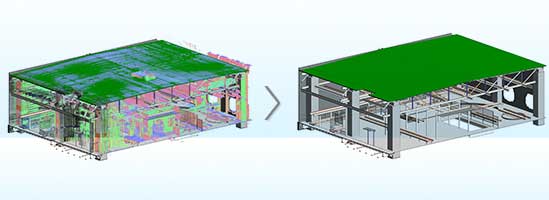
A building survey company specialized in design, construction, and management solutions partnered with TrueCADD for a retail coffee outlet project in the US. Point cloud Scans to Revit 3D modeling services were required from the team. With input from the client including point cloud Data drawings, scans, and 360 photos, the team at TrueCADD created deliverables that included an As-Built Revit model, pdf files with elevations, ceiling plans, floor plans, and coversheets.
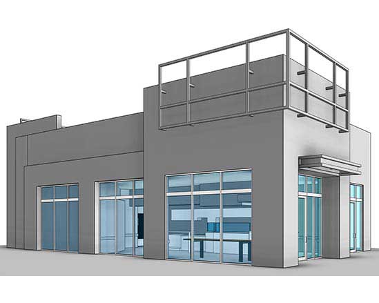
Revit 3D Model Converted from Scan Data
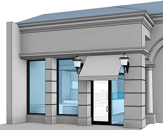
Entrance Elevation Details
A topographic services company from Europe approached TrueCADD for a commercial building project. Point cloud Files were provided as input to the team at TrueCADD. Point cloud Data was successfully converted to Architectural Structural models and 3D CAD output was taken from Revit software.
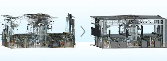
Point Cloud to 3D CAD Revit Model
Point Cloud to BIM Model
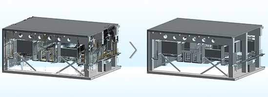
Point Cloud to CAD Conversion
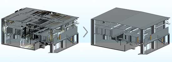
Scan to 3D CAD Model
Conclusion
Scan to BIM has numerous applications including architectural visualization, structural analysis, and other areas. Through advanced algorithms and software, point cloud to BIM or scan to BIM has driven cost-effective projects, enhanced safety, and reshaped construction practices. Partnering with Scan to BIM Companies to adopt advanced technology and tools is important for achieving excellence, efficiency, and sustainability in construction projects.
FAQs related to Scan to BIM
-
Scan to BIM reduces construction costs by improving project performance and efficiency. Accurate and information-rich 3D models generated from laser scans reduce errors, fuel precise planning, and lower material waste. Clash detection identifies interferences quickly, reduces rework, and expenses. Streamlining processes shortens renovation and retrofitting timelines and saves labor costs. Optimized resource allocation leads to budget friendly renovation and retrofitting.
-
Scan to BIM technology improves construction safety management through detailed 3D models of existing buildings. These 3D models promote virtual inspections and identifying potential hazards before onsite work begins. Interference detection capabilities prevent clashes between existing components and new ones to ensure a secure environment. Precise spatial information supports of safe workflows, reduces accidents, and improves overall site safety.
-
Scan to BIM plays a significant role in As-Built documentation for AEC projects as converting accurate and detailed point cloud data into precise 3D BIM models provides data-rich and high-quality visualization for architects, engineers, surveyors, contractors, and other involved parties. As-built verification ensures designs align with the existing structure.
Furthermore, point cloud to BIM captures intricate details that allow in-depth documentation of existing conditions and create detailed records that are used for expansions, modifications, and maintenance with complete project accuracy.

Harika Singh
Harika Singh is a published author with over 20 years of experience working with leading organizations in India and the United States. She develops authoritative content on BIM, CAD, VDC, digital engineering, and construction technology. Her expertise lies in translating complex technical concepts into actionable insights that help AEC professionals improve collaboration, efficiency, and project outcomes.
Related Posts
Need help on an ongoing basis?
We establish long term business relationships with clients and are committed to total customer satisfaction.
Home |
Sitemap |
Privacy Policy | Data Security & Confidentiality |
Contact us |
![]()